
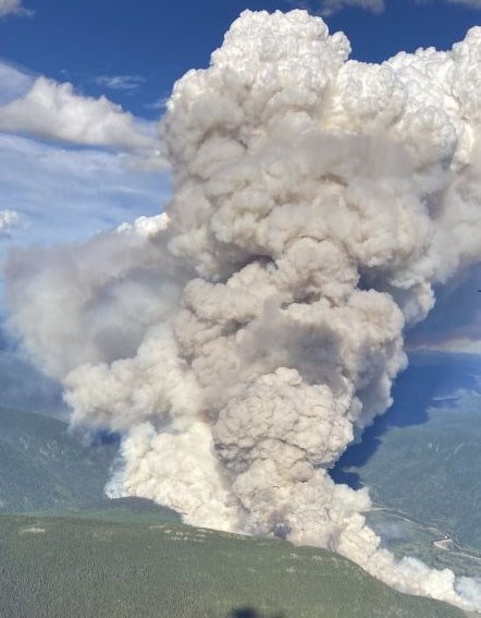
A wildfire between Mackenzie and Chetwynd that tempoararily closed Highway 97 in both directions, has destroyed structures and damaged a hydro power line.
The Pine Pass blaze discovered Friday grew from 150 hectares to 2,000 hectares overnight. Poor visibility caused by the smoke kept air tankers grounded.
There were some structures lost on Friday during the rapid fire growth. The BC Wildfire Service has yet to release details on what buildings were affected by the vigorously-burning fire, which is suspected to be human-caused.
A stretch of Highway 97 starting at 32 kilometres north of Pine Pass summit and continuing to 44 km south of Chetwynd was closed for about a day but reopened to traffic Saturday afternoon. But that is subject to change and motorists using the highway are being asked to check the Drive BC website for further updates.
Ten firefighters and three helicopters on the scene, as well as a structure protection unit.
“Crews and structure protection personnel worked through the night to deploy structure protection equipment in the area,” said BC Wildfire Service information officer Alex Lane.
“Today, crews are continuing with structure protection for structures along Highway 97 and are continuing to protect wooden power poles in the area. Crews are working to contain the fire to the north side of the highway.”
BC Hydro spokesperson Bob Gammer said while there were outages reported in the area and 15 customers were left without power, the three 500 kilovolt transmission lines that run south to Vancouver have not been damaged by the fire.
“It is burning parallel to the transmission line right-of-way in the Lemoray area just north of the Pine Pass,” said Gammer. “Those lines are part of the backbone of the provincial power grid and they are upon large steel towers. We did a visual inspection of those lines this morning by helicopter and none of the (BC Hydro) structures appear to be damaged, however, heavy smoke from the fire did reduce the visibility, so as best we can tell there were no structures damaged.”
The fire damage is at the end of a distribution line that starts in Chetwynd. That line is usually supported by wooden poles and the impact of the fire has interrupted power to area, which has a Ministry of Transport and Infrastructure/road contractor work camp in the vicinity of Lemoray.
“We don’t have residential customers configured to a transmission line, it’s not configured that way,” said Gammer. “So we are working closely with the BC Wildfire Service to monitor the fire and any impacts to the transmission line right-of-way. We are planning another overflight by helicopter (Sunday) morning as well.
“Where those power lines run, we keep that ground clear of trees so that we don’t have issues with them growing up into the power lines or falling on to the power lines. Right-of-ways are typically wide swaths cut so there’s nothing growing near these transmission lines and that does reduce fire risk.”
If the transmission line was damaged by the fire, Gammer said there’s enough redundancy built into the provincial grid system to divert power from the Revelstoke or Mica dams on the Columbia River or other areas of the province to feed electricity to where it is needed.
Closer to Prince George, the Cutoff Creek fire southwest of Vanderhoof which sent plumes of smoke to the city Friday afternoon has grown significantly in the past 24 hours and that prompted a health advisory which remains in effect. Fanned by winds from the southwest, the eastern border of the fire was pushed to within 55 km of Vanderhoof.
The Regional District of Bulkley Valley, Saik’uz First Nation and BC Parks on Friday issued an evacuation order which includes an area 44 kilometers on the Kluskus Forest Service Road, east to the west end of Frank Lake, south to the south end of Hay Lake, east to 11 km on the Red Road, then back north to 44 km on the Kluskus Forest Service Road including a portion of Finger-Tatuk Park.
An evacuation alert was expanded (see attached map). The BCWS has 65 firefighters, three helicopters and 12 pieces of heavy equipment dedicated to fighting the fire, which remains out of control.
Northeast of Prince George near Tumbler Ridge, the Tentfire Creek wildfire discovered on July 1st is still burning and covers 2,800 ha. Hot and dry conditions over the past week increased fire activity.
“That smoke was highly-visible from Tumbler Ridge and in that area,” said Lane. “We do still have crews on site working on that fire.”
In its latest report, the BCWS noted there were 21 firefighters, three helicopters and three pieces of heavy equipment involved in the Tentfire Creek fire.
In the Okanagan, vacationers and non-essential travelers are being advised to stay away Armstrong, Spallumcheen, Enderby, the Okanagan Indian Band territory and part of the North Okanagan which are under threat by the 58,000 ha White Rock Lake fire.
On Thursday, the entire town of Logan Lake, between Vernon and Merritt, were ordered to evacuate when the 38,000 ha Tremont Creek fire came within five km of the townsite.


