
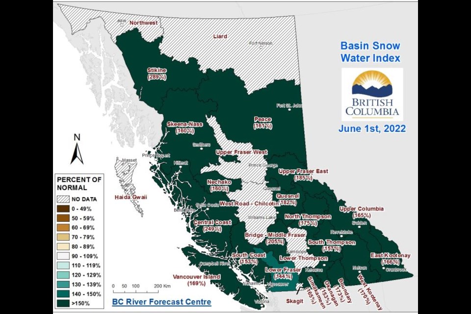
The Upper Fraser remains exposed to a high risk of flooding due to an unseasonably-high snowpack, according to an update from the B.C. River Forecast Centre, issued Wednesday.
As of June 1, measurements among eight stations in the Upper Fraser East added up to a snow-water equivalent of 635 millimetres, 185 per cent of normal for that time of year and up from 137 per cent as of May 15, when the snow-water equivalent stood at 787 mm.
As well, the station at Revolution Creek measured 271 per cent, based on a snow-water equivalent of 1,127 mm, making it one of six across the province where a record high was recorded.
The Nechako, meanwhile, stood at 160 per cent, up from 132 per cent as of May 15, while further south, Quesnel-Middle Fraser was at 182 per cent, with a 630-mm snow-water equivalent, up from 149 per cent as of May 15. A record 211 per cent of normal was recorded at the Yanks Peak station, based on a 1,075 mm snow-water equivalent.
A high streamflow advisory from Quesnel south was issued Wednesday.
The situation was similar across most of the province as measurements averaged out to 165 per cent of normal. Measurements above 140 per cent indicate a significant risk of flooding.
While about half of the snowpack will have typically melted by June 1, roughly 80 per cent remains, the RFC said, as extended cooler weather in April and May delayed the melt by two to four weeks.
Prince George Airport measured the fourth-coldest April and the fourth-coldest and third-wettest May on record with data beginning 1943, the RFC also noted.
With the snow pack having reached its peak on April 28, weather will determine the timing, magnitude, and rate of melt going forward. On that note, the RFC is predicting seasonal-to-below-seasonal temperatures through the province and continued unsettled conditions
"The significant risk over the short-term is for potential heavy rain to fall on a melting snowpack," the RFC added.


