
The wilderness around Prince George, out into the Robson Valley and up towards the Pine Pass has been home to plenty of hammering and sawing and digging and clearing to go along with the hiking, snowshoeing, skiing and mountain biking.
Thanks to an army of volunteers and contractors, new cabins have been built, old ones have been renovated, new trails have been cut and existing ones improved over the past few months and years.
A pandemic-induced rise in interest in getting outside has helped spark the activity. That and simply a need to bring decades-old cabins and other destinations up-to-date.
The Prince George Backcountry Recreation Society (PGBRS) has led the charge. The group has been behind upgrades to Red Mountain cabin and the historic Tacheeda Lookout and installation last fall of a long-awaited bridge over the creek at the start of the trail up Fang Mountain.
Out toward McBride, a new cabin is now nestled at the foot of the Ozalenka Valley due to the efforts of the Ozalenka Alpine Club and a new cable car is now in place along the Goat River Trail, the work of Dunster-based Fraser Headwaters Alliance.
Up in Mackenzie, the finishing touches are being put on a new trail that takes mountain bikers into the alpine, a project taken on by the Mackenzie Outdoor Route and Trail Association.
Closer to Prince George, progress is being made on a new layout of single-track trails on Tabor Mountain, backed by the Association of Caledonia TrailBuilders. And volunteers affiliated with the Caledonia Ramblers remain busy maintaining trails, with an extension of the plankway along a particularly muddy section of the trail up to Viking Ridge among the hiking club's most-notable projects.
If a theme has emerged, it's that getting the all-clear from various authorities can take up as much time as it does to raise the funding and get the actual work carried out - and sometimes even more.
A case in point was the bridge over Fang Creek.
"It was almost two years of authorizations and paperwork for an 18-foot bridge that's two feet wide," said PGBRS president Alex Bevington with a laugh.
He was quick to add that being sure to jump through the hoops and making sure everything is in place was worth the effort, particularly since it is now a "legal, long-term piece of infrastructure."
"It's better to do it the right way than just build something and have consequences," Bevington said.
Another theme of note is to do with the funding. While crowdfunding and community gaming grants played roles, the provincial government, through its Community Economic Recovery Infrastructure Program (CERIP), and Northern Development Initiative Trust (NDIT) have been major contributors.
Volunteers still helped out but most of the work was done by workers hired by contractors as the projects were turned into noticeable job creators. Helicopters have also come in handy when it has come to getting material onto the sites, but they come at a cost.
Either way, the patience and perseverance has been paying off.
Here's a closer look at the various projects that have been completed or are in progress, plus a few others that could come into fruition going forward, starting with those that PGBRS has taken on:
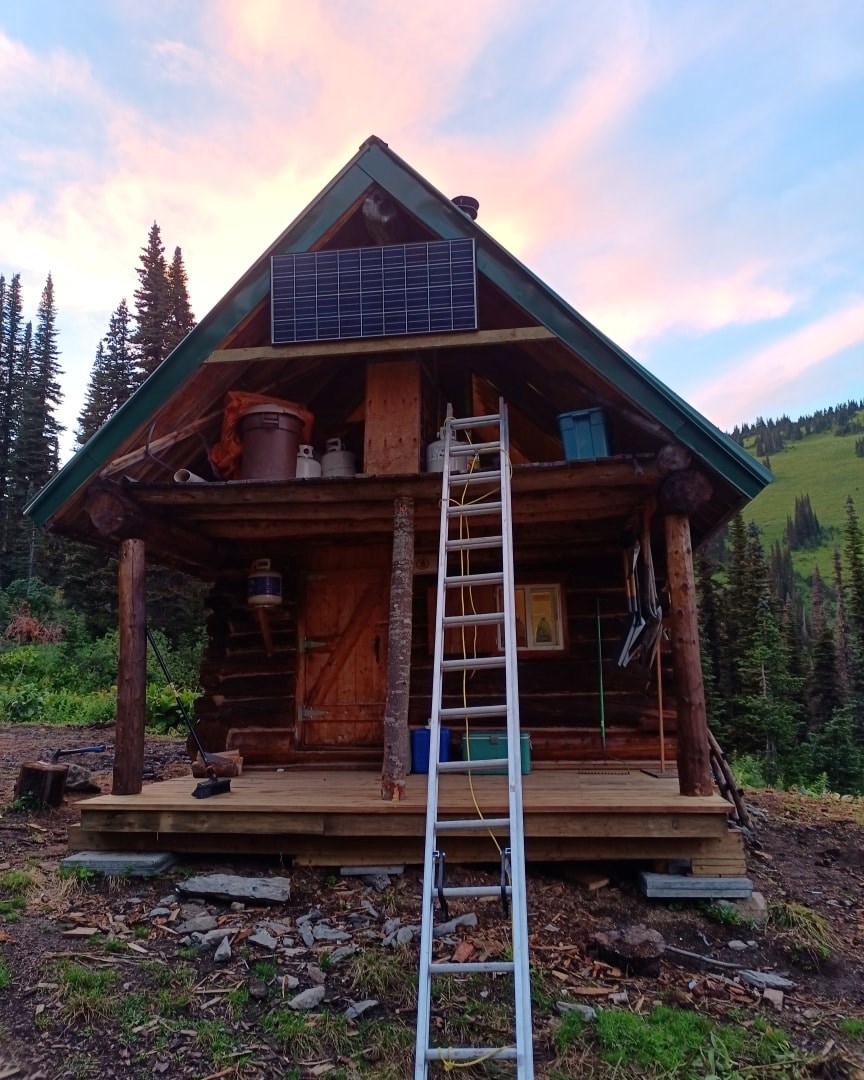
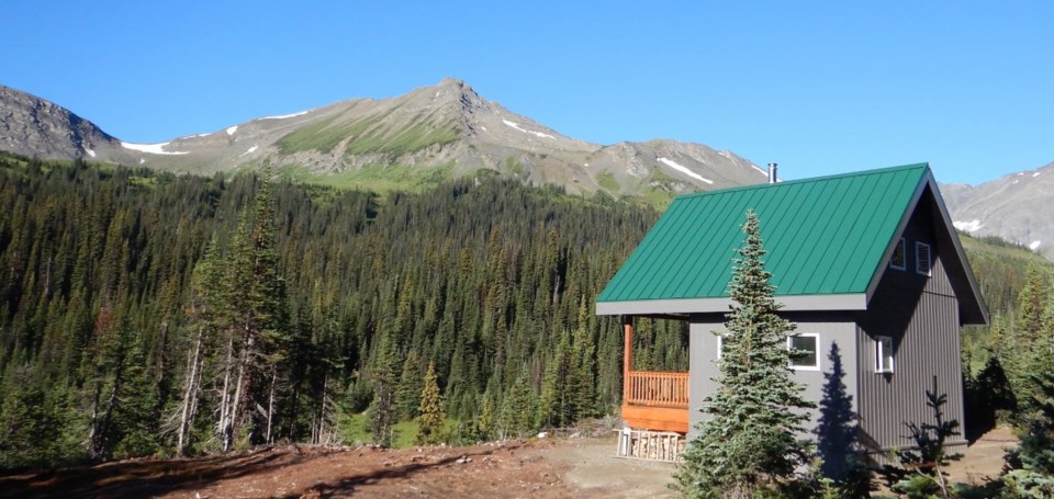
Red Mountain cabin: Originally constructed in 1962 by the folks living in Penny, it was beginning to show its age when, in 2006, the PGBRS embarked on a major renovation. A new A-frame roof was installed and the interior updated and perhaps most important, it was raised off the rocks and onto a set of logs.
The work didn't stop there. In 2018, new floors were put in place and, this past summer, the foundation and bottom logs were replaced, the exterior logs were refurbished and a new porch and solar panel system installed.
As well, a helipad and a new outhouse were constructed and cables were attached to the cabin and anchored to the bedrock as a way to keep the cabin from shifting under the snow loads.
The decision to renovate rather than "knock it over and rebuild it" was made easy by the fact that it is located on the only good building spot in the area, said Bevington.
The most-recent work cost $101,000 with NDIT contributing $71,000 while a further $25,000 came out of booking fees accumulated by PGBRS from users over the past years and $5,000 came from the provincial government through Recreation Sites and Trails B.C.
"It was expensive but we had a mini-excavator up there digging a new outhouse, lots of helicopter time, so even a modest renovation costs a lot in the mountains," Bevington said.
But it's a popular spot. Within 10 minutes of being opened to reservations, the cabin was complete booked although Bevington also noted that with free cancellations up to a week ahead, it's still worth visiting the PBRS website for last-minute openings.
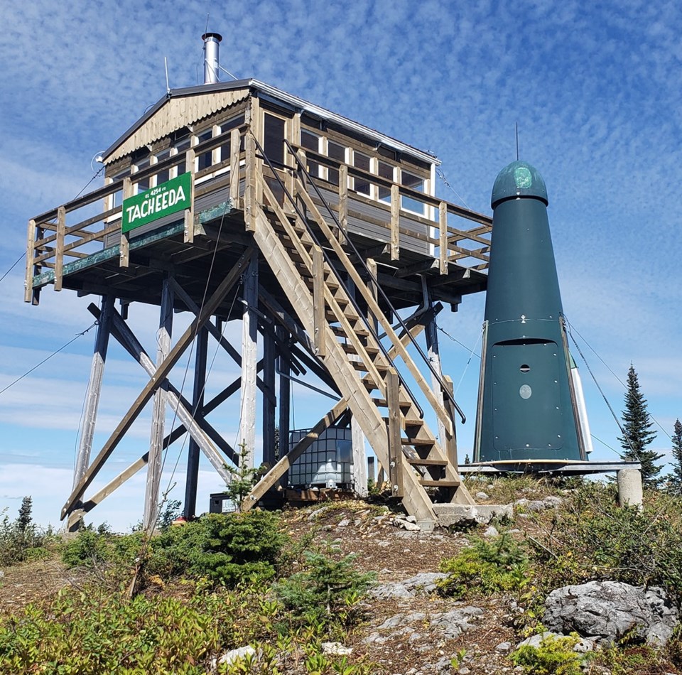
Tacheeda Lookout: At 60 years old, the forest fire lookout was getting rickety to the point of dangerous but still provided a panoramic view of the surrounding mountain ranges and had value as a heritage building.
Getting approval for the work was "relatively straight forward," Bevington said, because it is located exclusively on RSTBC land.
PGBRS secured $145,000 from CERIP and went to work. Along with the actual renovation, the money paid for a heritage conservation plan and some engineering work before a contractor was selected through a bidding process.
From there, renovations were carried out in August beginning with an upgrade of the stairs and the surrounding deck. The interior also received a sprucing up and a wood stove was installed.
"The lookout is amazing now, it's in really great shape," Bevington said. "It's not an overnight cabin. Somebody could certainly stay there for the night but it'll be a great place to snowshoe in the winter, warm up by a fire and from there on a nice day you can see the whole Parsnip watershed and the big tributaries of the Hart ranges and the Northern Rockies and the Anzac and the Table."
The trail up is six kilometres one-way and the steady climb is rated moderate.
Getting there, however, can be another matter as the forest service roads leading to the trailhead have been exceptionally busy with industrial traffic due to pipeline construction, ongoing logging operations and railway operations.
Recreation Sites and Trails B.C. is advising anyone travelling these roads to be equipped with two-way radios so they can call out their kilometres as they make their way. As a fallback, groups can also wait for a logging truck or other type of vehicle and follow behind.
Looking ahead: PGBRS is not letting up.
Bevington said BC Parks is reviewing a proposal to install a cable car across Ptarmigan Creek, so hikers would no longer have to ford the swift and chilly waterway to get to the trail up Erg Mountain.
Complicating the matter has been the fact that, similar to the creek at start of the trail up Fang, Ptarmigan Creek is neither in an area administered by BC Parks nor by RSTBC. Bevington is bracing for a long referral process as a result.
"And if it goes through, then we'll have to fund raise and that will take another year or two," he said.
PGBRS' ambitions include establishing a cabin at Lavitah Mountain next to Ralston Creek, a popular ski area, in the southern extent of the Pine Pass and about 5-8 kilometres off Highway 97 North.
"It's not the biggest mountain in the Pine Pass, but it's very gentle and stable terrain. It would be a very cool place to build a cabin," Bevington said.
PGBRS is also in the early stages of getting approval to rebuild Longworth Lookout.
Located at the end of a steep but worthwhile seven-kilometre hike, the forest fire lookout dates back to 1938. Because the structure is on Crown land, the group will have to "start from scratch" in terms of getting the authorizations.
"It's totally run down, unfortunately, but we would love to build it into an overnight hut," Bevington said. "If you can picture it, just sitting the porch with that view off of Longworth Mountain, you see Baldy and the Robson Valley and all the mountains, it would be just spectacular.
"And you could even hut-to-hut with Red Mountain. You could spend one night on Longworth and then hike over the Red, which would be a really cool way to see the landscape."
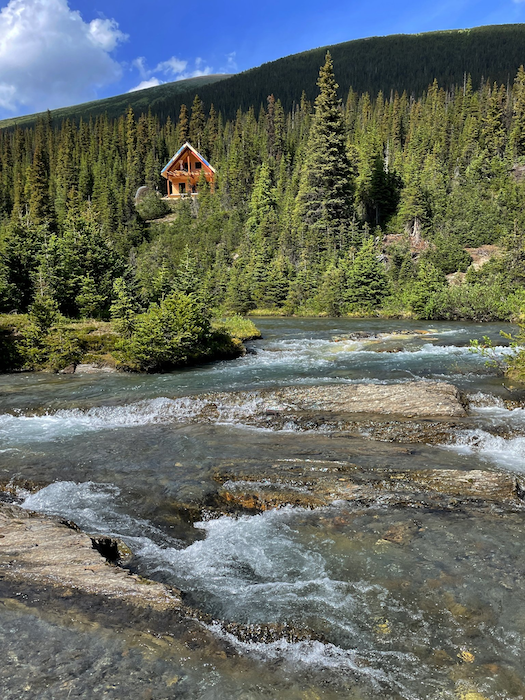
Ozalenka Valley Cabin: The new digs at the foot of the scenic Ozalenka Valley west of McBride replace a cabin built more than 30 years ago and on a "shoestring budget and on short notice."
A group of local people scrambled to put in a trail and put up a cabin after learning of a plan to log the area. The area remained untouched and a decade later the valley was incorporated into West Twin Provincial Park.
But the building was not without its drawbacks.
"By shoestring budget, I mean under $7,000," said Ozalenka Alpine Club president Jeff Corbett. "The helicopter was donated and it was built 100-per-cent with volunteer labour in November which was end-of-season, short notice.
"The foundation would never meet modern standards...you can't build that fast and that cheap and have a high-quality structure."
Fast forward to 2022 and an adjacent site is now home to a new and better cabin that should last many decades.
"Structurally, it's engineered to withstand snow and wind and everything that might come," said Corbett. "It's very well insulated and very watertight."
"Complete sheet metal roofing and siding to keep critters and mice and everything out and keep the structure dry so it doesn't rot."
That said, it remains a basic cabin.
"It's a shelter with a sleeping area," Corbett said adding that the "luxury items" are solar-powered lighting, a propane stove and a sink that drains into an underground field to keep the "grey water" contained and the surrounding area sanitary.
"We don't have running water in the cabin, you have to go to the creek to get that," Corbett noted.
The new cabin's foot print is slightly larger and provides enough room to comfortably sleep 8-10 people in a loft.
Between getting the approvals, completing the engineering and raising the funds, getting the project to the construction stage was a five-year process that took up more than 2,000 hours of volunteers' time by Corbett's estimation.
"The amount of paperwork, bureaucracy behind the scenes for these things is mind-boggling," Corbett said. "The government has to have a system of accountability for land use, otherwise it's a free-for-all and everybody does everything so I understand that.
"But the average person hiking down a trail has no concept of how much work it was to get that built and to maintain it...I have a much greater appreciation for any of these outdoor infrastructure than I used to before I was in leadership."
Getting the cabin built took a much-shorter five weeks with about half that taken up by putting in the foundation in 2020.
"Once all those pieces were in place, the actual building of the cabin was a short period of time," Corbett said with a laugh.
The project cost a little over $200,000. The OAC contributed $40,000 saved up from the booking fees generated through the old cabin and secured a community gaming grant of $100,000 while Fraser-Fort George Regional District, NDIT and BC Parks and a number of cash and in kind donations from private donors and local businesses rounded out the support.
About $60,000 went to helicopter time because all the materials were flown in. One contractor put the foundation in place two summers ago and the other erected the building on the foundation this summer.
The bill would have been much higher if not for the volunteer labour, which by Corbett's estimate made up about half the roughly 2,400 hours put in this summer to assemble and transport the materials and put up the cabin. The percentage rises even further once the behind-the-scene work from grant writing to fundraising is accounted for.
The seven-kilometre trail to the cabin is also being reworked after major flooding along the Fraser and Dore rivers spread to Ozalenka Creek. The creek changed course and is no longer flowing under one of the bridges, said Corbett, "so we are rebuilding just under a kilometre of trail to avoid that bridge...it's hikeable right now but it needs a little more work."
About a kilometre of trail two years ago due to water damage, Corbett added.
Looking ahead: Catching up on trail maintenance is on the agenda.
The OAC also has permission to build a new trail along the Holmes River to the Bench Lakes east of McBride and hopes to have it completed next summer. Distance will be five kilometres with an elevation gain of 1,500 feet rising to 10-12 kilometres and 3,500 feet once a road leading to the trailhead is no longer in use.
"We're still going to be busy," Corbett said.
.png;w=960)
Goat River Trail: Hikers can be rest assured they can safely cross the Goat River via the cable car following upgrades completed a year ago.
"The supports are new and the cable's new and it's firmly anchored now whereas before it was hanging on a couple of trees...so this is really solid and substantial," said Roy Howard of Fraser Headwaters Alliance.
The Dunster-based group was able to move forward with the work after landing a $203,000 grant from CERIP.
Not all that money was spent on the cable car. Next up is a rerouting of 17 kilometres of the 68-kilometre trail that runs from Crescent Spur to Bowron Provincial Park.
The route would no longer follow a series of old logging roads that date back to the spruce beetle outbreak some 30 years ago.
"Now they're brushing in and we can't keep up (with clearing them)," Howard said.
"It would be a lot easier with this new route that we're looking at. Quite a bit of it is up on a ridge top...and a little bit more of it would follow the original 1886 route of the trail."
It's known as the "Historic" Goat River Trail because it was originally commissioned in 1886 as a gold rush trail along the Goat River.
Howard estimates no more than 20 people a year walk the entire trail as it is currently routed but figures as many as 100 do the eight-kilometre round trip hike from the Goat River Forest Service Road to the cable car.
The reroute has also drawn support from the College of New Caledonia Research Forest Society’s legacy fund to the tune of $50,000 and $3,000 from the Yellowstone to Yukon Conservation Initiative.
But the work, which would be done by a hired crew, remains pending approval from BC Parks and RSTBC and Howard is on pins and needles.
"I think if we can get off the old road there and let it get back to natural vegetation, that would be good, and then we would just have to work out some details on exactly how it's going to work," Howard said. "There might be a water issue there because it's a pretty dry ridge...we might have to fly in a tank of water every year."
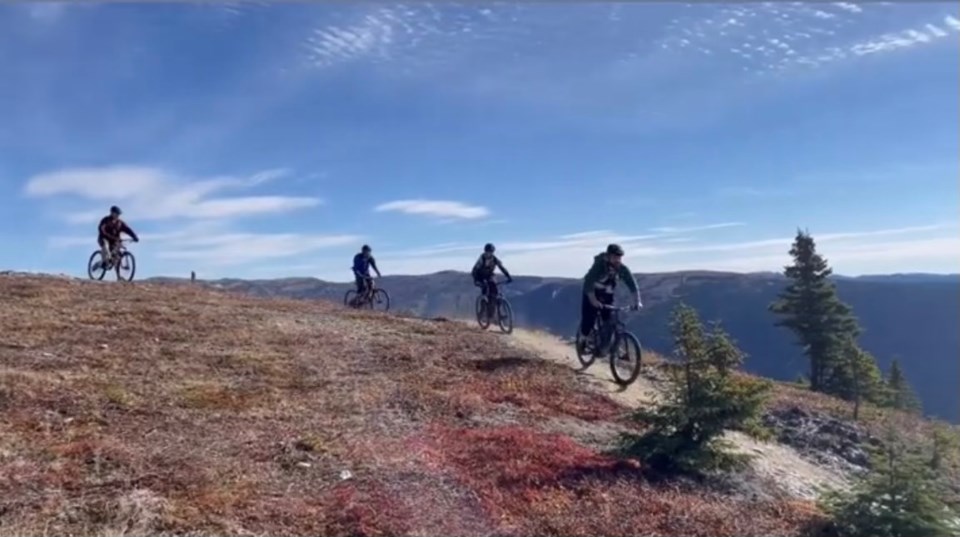
Morfee Mountain Ridgeline Trail: Mackenzie is on the verge of becoming home to B.C.'s longest shuttle-access downhill mountain biking trail.
Once completed, the Morfee Mountain Ridgeline Trail will cover 13.6 kilometres with 850 metres of descent. It's divided into four sections plus an access trail at roughly the midway, each named after a type of fly-fishing lure.
As of this summer, peddlers have been able to enjoy a 6.4-kilometre ride (12.8 kilometres round trip) through the alpine with view of the Northern Rockies via the trail's upper section, known as Royal Coachman. The section, which is reached via a drive up Morfee Mountain Road, is a cross-country ride and rated green or easy.
And at the bottom, Parachute Adams, a 1.9-kilometre section with a 179-metre drop and rated blue or intermediate was also opened. The plan is to have one more section open by this fall - Copper John (1.7 kilometres, 175 metre descent, black diamond or difficult) - plus Egg Sucking Leech, the 914-metre up-track access to Copper John.
Still in the works is Woolly Bugger, a 3.6-kilometre midsection with a 391-metre descent, rated blue. It also features a spur that takes riders on a 125-metre black diamond or difficult run followed by a 103-metre easy return to the main route.
What's in place so far has attracted plenty of attention and accolades, according to Mackenzie Outdoor Route and Trail Association (MORATA) president Ross Hobbs.
"Over the last month, I've noticed people driving up from Prince George pretty much every weekend," Hobbs said. "Some of the feedback is 'this is amazing, why would we go to Whistler to ride, for instance, Lord of the Squirrels, when you could ride something two hours away from Prince George that's just as good?'"
Also in the job jar are the finishing touches on the 10.8 kilometre Azan Trail around the perimeter of the town itself. The remaining 2.1 kilometres should be ready by next year.
The work on the mountain biking trail has been aided by a $460,000 grant from CERIP while $150,000 was secured for the Azan project, with NDIT contributing $100,000, the District of Mackenzie $30,000 and Northern B.C. Tourism $20,000.
The Ridgeline series of trails involved three years of planning followed by a roughly two-year wait for the approvals. Once those were secured, MORATA had two years to raise the funds and get the work off the ground. On the bright side, CERIP financed the entire project.
"It would have been extremely difficult to do it piecemeal, in smaller sections," Hobbs said.
The town is also home to a 15-kilometre trail around Morfee Lake with a spur into Morfee Falls.
Tabor Mountain Single Track Trails: Better-than-expected progress by members of the Association of Caledonia Trailbuilders has produced nearly-five kilometre loop of single-track trail, complete with a boardwalk over a wetter section, and then some.
With the help of rented mini-excavators and some know-how among the membership, they were able to complete plenty of preparatory work prior to the contractor coming in. As a result, they have made the $107,000 worth of direct and in-kind funding generated for the project's initial phase go farther than originally anticipated.
"Right now, we have a rideable trail of almost five kilometres," said ACT president Dan Domes. "Some improvement on the smoothness of the track in some places needs to be done yet - some of it is pretty rocky and that's what we've hired a contractor to do. But I have ridden on my bike, and it's a lot of fun and it can be ridden up and down.
"And we have a really amazing blue downhill trail with a black variation on it - you can take off (the blue) and do the black variation and come back onto the blue - that was built by a local trails contractor and it's getting rave reviews."
Weather pending, they also hope to have in place before the season ends a 1.5-kilometre expert-level downhill trail from the upper portion of the mountain and connecting to the portion down below.
The trailhead is at the foot of Groveburn Road in the northwest corner of the Tabor Mountain Recreation Area, a 15-minute drive east of Prince George. In addition to mountain bikers, the trails are also open to runners, hikers and snowshoers.
At $70,000, Northern Development Initiative Trust was the biggest contributor to the work done so far, followed by $18,000 from the Fraser-Fort George Regional District. RSTBC has also been very supportive as has Lheidli T'enneh, said Domes, who noted the trails are being builty on the First Nation's traditional territory.
The first phase is part of a grander plan to create a 35-kilometre system of single-track and members of ACT will be busy fundraising over the winter in the name of building more trail once the snow has melted.
"We're really happy with the start we've made, it's exceeded our expectations and we want to just keep growing," Domes said.
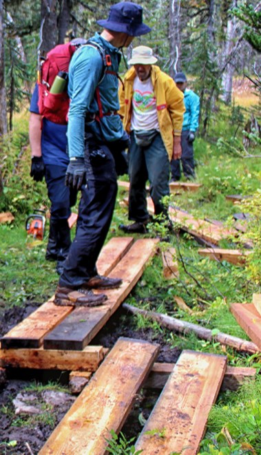
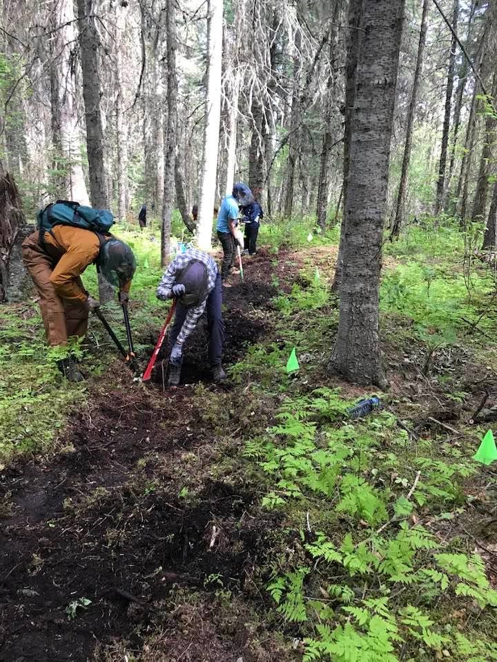
Caledonia Ramblers: Members of the hiking club have also had a passion for building, maintaining and improving trails.
One of the jewels in that crown has been the installation of cedar planking through the meadow on the trail leading up to Viking Ridge.
Over the course of two "work hikes" - one held in each of the past two summers - volunteers have put in about 1,000 feet of boardwalk with half at the far end of the meadow and half at the start.
Through its park enhancement fund program, BC Parks contributed $6,300 to pay for the lumber and cover the cost of flying the material in by helicopter.
Convincing BC Parks to contribute was an easy sell, according to long-time Rambler Dave King.
"It's a very popular trail and they were very aware from popular feedback that there are muddy sections up there," King said.
More work still needs to be done.
"We'd like to install another 500 feet minimum and there is probably room for another 1,000 feet," King said. "We would've done more this year but the planks just weren't there due to a shortage of cedar."
Cedar is preferred because of its resilience to moisture.
"Anything else and you've got to pressure treat it and as soon as you start cutting a piece of pressure treated wood, (it doesn't work,)" King said. "Douglas fir will stand up for quite awhile but most other things, after a period of time it's gonna rot whereas cedar may last 25 years."
King said he has put in another order for cedar in anticipation of drawing more funding from BC Parks to further extend the planking next summer.
The club has also been busy putting in cedar planking along the wetter parts of the historic Giscome Portage trail, north of Prince George.
The 8 1/2-kilometre path from Huble Homestead to Barney Creek Road at Highway 97 North crosses the crossing the Continental Divide, which separates the Pacific and Arctic watersheds.
Well used by Indigenous people, it came into particular prominence during the 1860s when, according to BC Parks, discovery of gold in the Omineca and Peace regions "created a demand for quick and efficient access to the goldfields." It remained the main route to northern B.C. until the 1920s when a road was built between Prince George and Summit Lake.
The trail has always been very wet.
"When used as a wagon road in the early 1900s, some sections had logs laid on it and covered in soil," said King. "Most are now gone to rot and that was why we thought of installing plankway though the wettest parts."
In 2018, he approached Enbridge, whose natural gas pipeline runs through the area, about buying cedar lumber and maybe lifting it into the key spots by helicopter. Enbridge agreed to help and over three years, about 1,800 feet of two-board planking was installed, some with help from about a dozen company employees.
In 2021, with more help from Enbridge and BC Parks, a new bridge was constructed over Tay Creek at about the halfway point. And this year, a further 500 feet of plankway was installed, also lifted in by helicopter contracted by Enbridge.
There are still a few wet and muddy sections, "but minor compared to what it use to be like," said King.
"We will continue to remove blowdown via our agreement with BC Parks. For users of the trail, June and July are not good months as mosquitoes and blackflies are bad.
"But it is good trail for late summer and fall hikes and is good for snowshoe trips. There is a good chance of seeing moose and other wildlife."


