
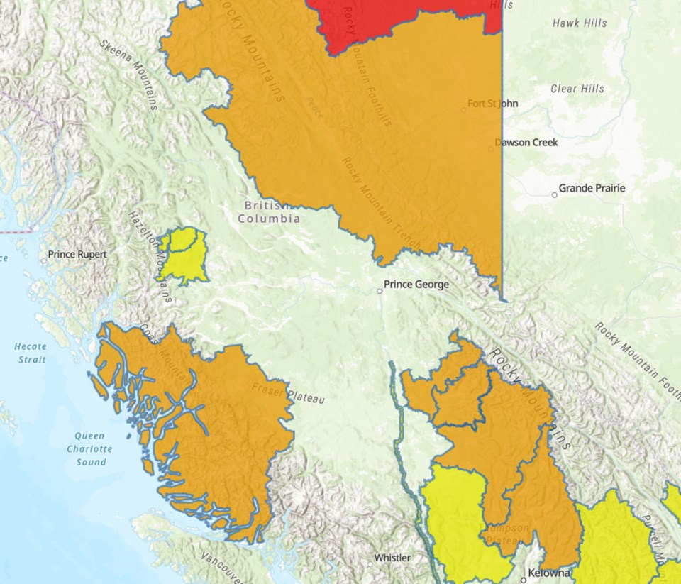
On Friday, the B.C. River Forecast Centre issued a flood watch advisory in the Peace country, including tributaries of the Peace River around Fort St. John, Chetwynd, Moberly Lake, the Pine Pass, Hudson’s Hope and Dawson Creek and along the Quesnel River near Quesnel and Likely.
Further north, a flood warning is in effect on the Liard River near Fort Nelson.
“A low-pressure system is impacting the Peace Region with rainfall. Precipitation amounts around 10-40 mm have been observed through the region since yesterday, and additional rainfall expected through Friday,” the flood watch advisory says. “Rivers are expected to rise rapidly on Friday in response to rainfall. Smaller creeks are already showing signs of rapid rise. Flows are expected to reach peak levels late Friday, and into Saturday/Sunday for larger watersheds.”
In the B.C. interior, including the Quesnel River basin, the combination of snow melt and rain is causing high river levels, the River Forecast Centre warned.
The River Forecast Centre is warning the public to stay clear of fast-flowing rivers and riverbanks, which may become unstable during high water levels.
In addition, a high streamflow advisory is in effect along the Fraser River from Quesnel to the Pacific Ocean. High streamflow advisories have also been issued for the Bulkley River near Smithers and the Telkwa River near Telkwa, west of Prince George.
“With significant mountain snowpack remaining in the Fraser River headwaters, flow may remain elevated for an extended period over the next 1-2 weeks,” the advisory, issued on June 15, said. “During this period, the river will remain vulnerable to extreme weather events, in particular heavy rainfall or extreme heat.”
A flood watch is also in effect along the central coast, near Bella Coola, for the Bella Coola River, Dean River and their tributaries.
In a media briefing on Friday, Dave Campbell, the head of the B.C. River Forecast Centre, said the remaining snowpack in the Fraser River basin is “double the normal snowpack for this time of year.”
Upstream of Prince George, in the Upper Fraser East basin, the snowpack was 261 per cent of normal as of a June 15 report by the River Forecast Centre. Data for the western portion of the Upper Fraser basin wasn’t available.
“We are very much in the peak window of freshet… as the remaining snow continues to melt,” Campbell said. “We’re in that period of high flows, and we are vulnerable if we get hot weather.”
Campbell said he expected water levels on the Fraser River to hold steady for a few days, before beginning to rise.
Currently Environment Canada isn’t forecasting a big rise in temperatures in July, meteorologist Armel Castellan said, but the chances get higher later in the summer.
Emergency Management BC senior regional manager Ian Cunnings said the province is experiencing localized flooding in several areas, and 584 people across B.C. are currently on evacuation alert.
The province is moving resources, including hundreds of thousands of sandbags, into position to respond to the risk of flooding, Cunnings said. However, he urged residents in flood-prone areas to plan where they would go if they needed to evacuate and pack a “go bag” with essentials including medications and important documents.
“If evacuation orders are issued, follow all orders by the First Nation… or local government,” he said.


.png;w=120;h=80;mode=crop)