
Prince George people returned to work Wednesday morning after the Canada Day holiday, and thankfully we weren’t talking about what might have been a damaging tornado touching down and wreaking havoc on the city.
But there was a real chance it could have happened.
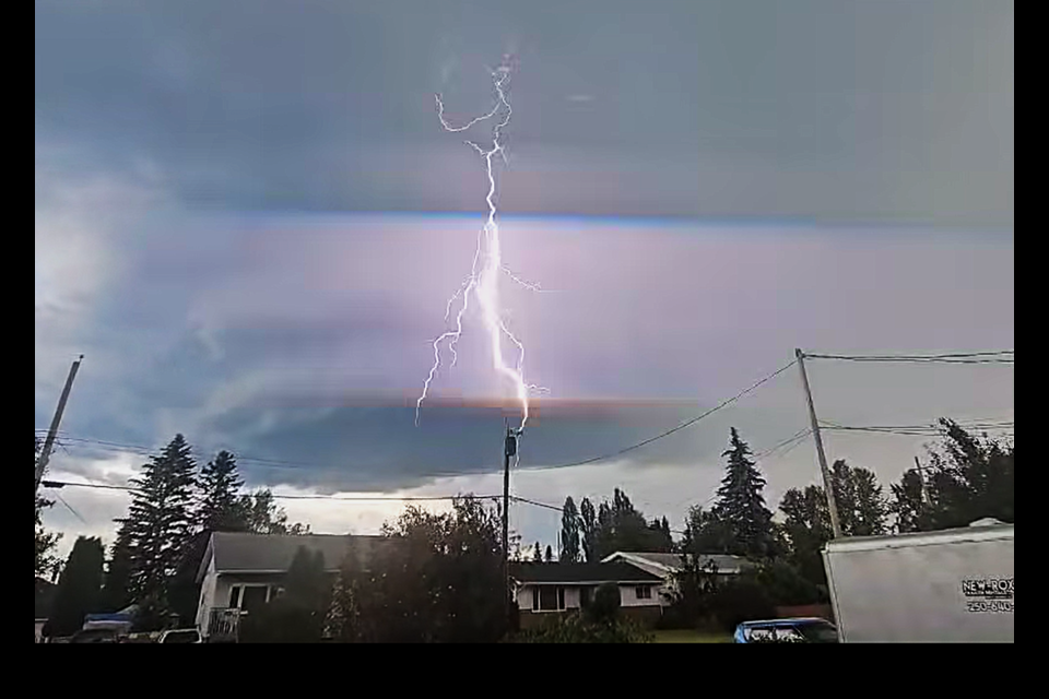
That’s why Environment Canada issued a tornado warning for the city at 8:18 p.m. Tuesday, advising residents to take immediate cover in a basement or interior room and be alert for flying debris, in case the severe weather threat materialized.
Fortunately, by the time most residents saw the warning on their phones, the thunderstorm had already tracked northeast into a sparsely populated area.
“Last evening, there were some thunderstorms that popped up in central British Columbia, and one in particular was noted on radar to have a signature conducive to rotation in a thunderstorm — what we call a bounded weak echo region,” said Environment Canada meteorologist Matt Loney, based in Edmonton. “This prompted a radar-based warning.”
At the time the alert was issued, the worst of the storm had already passed through Prince George. Residents took to social media noting it wasn’t even windy when the alert hit their phones.
“When you get phone-based warnings, they’re geolocated with reference to the forecast region,” Loney said. “In future, that should change so it’s only people in the immediate vicinity (who receive alerts). The storm was actually a few kilometres northeast of Prince George and moving toward the northeast at 50 kilometres an hour.
“Had the storm been forming from the southwest, it would have been much more alarming. But it was already east of the city, moving into a less dangerous area, luckily.”
Earlier Tuesday, Environment Canada had warned of the potential for severe thunderstorms in the afternoon. Daytime temperatures reaching 28 C generated convective currents that led to heavy rain, nickel-sized hail and lightning activity later in the day.
Doppler radar at Prince George Airport detected rotating updrafts — or mesocyclones — during the storm. These were caused by wind shear, where winds moved in opposite directions toward and away from the radar, triggering the tornado warning.
There were no reports of funnel clouds forming or touching down, and the severe thunderstorm warning ended at 9:45 p.m.
Loney said the Northern Tornadoes Project at Western University in London, Ont., will conduct a follow-up study to investigate further.
Radar in northern BC is monitored 24/7 by Environment Canada, and Loney said the turnaround time from detecting a threat to issuing a warning is typically within five minutes.
However, northern BC has few radar stations and many sparsely populated areas, increasing the chance of tornadic activity going unreported.
“We do have tornadoes in BC from time to time — more than we think — simply because we tend to live in valleys and the surrounding terrain is mostly uninhabited,” Loney said. “So, there’s likely a lack of confirmed sightings.
“There are undoubtedly cells that produce weak tornadoes our instruments and surveillance don’t pick up.”
BC’s mountainous terrain and proximity to the cool Pacific Ocean generally make it less prone to the powerful thunderstorms common in the Prairie provinces. Flat topography in those areas allows storms to gain strength and duration.
Prince George isn’t part of “tornado alley,” but it sits in a corridor that experiences more thunderstorms than much of the province.
The city averages 32.9 days annually with lightning detected within 25 kilometres — the third-highest in BC, behind Castlegar (36.5 days) and Cranbrook (33.9 days).
“That strip through central BC is more prone to thunderstorms, which can give birth to tornadoes,” said Loney.
On May 21, a weak landspout tornado was detected northeast of Vanderhoof. No injuries or damage were reported.
More violent tornadoes are typically spawned by supercells — large rotating thunderclouds — or when multiple cells converge. These usually require about an hour to gain enough rotation to touch down.
Straight-line winds, also known as derechos or plow winds, can also occur during thunderstorms. These gusts, dragged downward by precipitation, can be strong enough to flatten swaths of trees.
Canada averages 63 tornadoes per year. Ontario leads with an average of 18.2, followed by Saskatchewan (17.4), Alberta (15), Manitoba (10) and Quebec (four to eight). B.C. averages fewer than one per year.
Canada’s three deadliest tornadoes were all rated F4 on the Enhanced Fujita scale, with winds between 267 and 322 km/h:
- Regina, June 30, 1912: 28 people died, $103 million in damages (2024 dollars)
- Edmonton, July 31, 1987: 27 deaths, $771 million in damages
- Windsor-Tecumseh, Ont., June 17, 1946: 17 killed, $163 million in damages
Loney, who studied at the University of Oklahoma and chased nine tornadoes during that time, says BC residents should be aware tornadoes can happen here.
“People should have in their emergency awareness that tornadoes do happen in BC, and they should know what to do,” he said. “Take cover, go to the basement if you can, stay away from walls and windows. Try to get out of your car — being in a vehicle during a tornado can be dangerous. It’s better to be in a low spot on the ground.”
He also warned against the common myth that sheltering under a highway overpass is safer.
“A tornado’s funnel effect will reach under the bridge, and parking under an overpass — especially when visibility is low — can cause traffic jams and motor vehicle accidents,” he said.
There are unconfirmed reports of a tornado touching down in Prince George as recently as 1994.
If you experienced that storm or have information about any other tornado to touch down in the area's history, please contact Citizen reporter Ted Clarke at [email protected] or call 250-960-2764.


