
Nourse-Allin Creek Trail
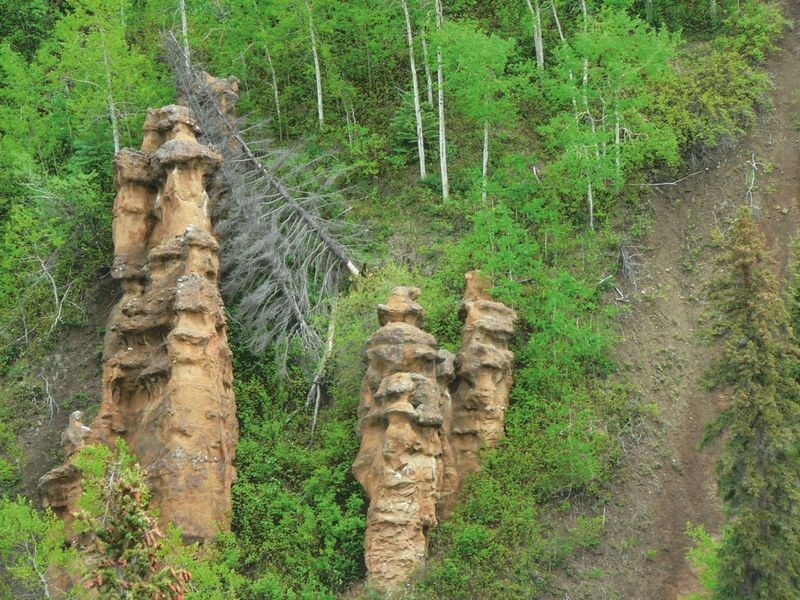
This week's hike is another early season gem that has a surplus of geographic features. The first section provides a glimpse of Nourse Creek, carving its way through a rock canyon and plummeting down a narrow gorge. Shorty after this, there is an elevated view of the wind sculpted hoodoos perched high above Nourse Creek. It is possible to get up close and personal with another interesting feature, as a short trail leads down to the edge of a two metre high waterfall which is one of many on the creek. The remainder of the trail follows the meandering creek to the northern trailhead.
Directions
From the junction of Highway 16 and Domano Blvd in Prince George, drive 219 km west to the town of Burns Lake. Turn left onto Highway 35 in the centre of town. Drive 22.2 km south, and turn right onto Francois Lake Road. Drive 15 km along the lake, and turn right onto Henkel Creek Forest Road. Follow this road for 1.5 km, and turn right onto a side road. Continue 170 m further to the trailhead and parking lot.
Trail Description
The parking lot is situated in a clearing high above Nourse Creek. The trail leaves from the north end of the parking lot. The trail follows Nourse Creek for most of the route. There is a viewpoint overlooking the lower falls after 750 m. At 1.5 km, there is a short 50 m side trail to the upper falls. The trail splits into two parallel trails many times over the route. The trails were designed with the upper parallel trails to be used for horseback riders. The trails join together as one after distances of 50 m to 1 km. There is a major trail fork at 5.0 km, with the right fork heading a further 50 m to Nourse Creek where the bridge has washed out. In low water the creek is wadeable. In high water the left fork should be taken to avoid the crossing. The left fork continues for 1.0 km where another junction is reached. Left leads to a gravel pit and an access road that can be walked to the Maxan Forest Road trailhead. The right fork winds up a steep hill and back to the same Maxan Forest Road trailhead. If a decision is made to wade the river at the crossing at the 5.0 km mark, then the trail follows the east side of the creek for another 300 m where it is neccessary to wade across the creek again. The trail is relatively flat with rolling hills throughout. There are good views of Francois Lake near the beginning of the trail.
The trail was constructed in 1995 by the Lakes Forest District and Burns Lake Secondary School students. The trail is named after Matthew Nourse and Tom Allin who were early settlers in the area. The creek is known as either Nourse Creek or Allin Creek.
For more information on this hike and others in this area, including airphotos, maps, GPS coordinates and trail photos, refer to the book Hiking North Central BC which is available at local bookstores.


