
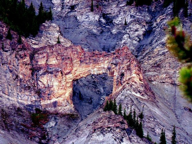
This week's hike is one of the more grueling treks in the region but the reward is worth the effort. This trail climbs up very steeply to a viewpoint of one of the most unique geologic features in the province. The natural stone arch is 18m high and 80m wide as it spans a large gully. The trail past the viewpoint continues up to the ridge above but there are a couple of technically challenging sections that must be crossed. For those who would like to view the arch but are not willing to tackle the steep trail, there is a highway viewpoint. There is a small sign on the highway just past the highway turnoff. The signs reads "Baker Creek Arch" and there is only a small 50 m section along the highway where the arch can bee see before it is obscured. The arch is now part of the Holliday Creek Arch Protected Area.
Directions
From the main intersection in McBride, drive 23 km east on Highway 16, just past a highway rest area on the right. Turn left onto a side road and drive 600 m to the Stone Arch Trail parking lot and trailhead. It is 230 km from the Yellowhead Bridge in Prince George.
Trail Description
The trailhead parking lot is located beside the trail sign for the Stone Arch Trail. The trail starts down the road, on the right just past the trail sign. The trail follows an old skid road through the forest for 800 m. It meets the junction of the Groeneveld Trail, which heads off to the right at this point.
Continuing straight ahead, the trail follows the banks of the Holliday Creek (aka Baker Creek). The trail has been rerouted in areas due to washouts during high water. At 1.9 km along the trail, there is an old trapper's cabin on the right side of the trail. The trail continues along the creek edge below a shale slope with unique rock formations above. At 4.4 km, the trail leaves the creek valley and starts a very steep ascent to the north. The trail up to this point was brushed out in the summer of 2005 and is in good condition. The trail follows a steep ridge to the 6.4 km point where the first views of the natural stone arch can be seen. It may be difficult to visualize the arch initially, if you do not know what you are looking for, as it blends in with the background of the mountain.
Continuing up the ridge for 7.5 km will lead to a point where a traverse across Baker Ridge can be started eventually leading to a descent down the Baker Creek Trail. It is a further 1.1 km to the start of the traverse from this viewpoint The trail up to the start of the traverse is more challenging. It is very steep and narrow, with a few large rock outcroppings that need to be circumvented. There are many signs of mountain goat from this point onward. Goat trails traverse across the slopes in all directions. Goat hair and scat can be seen along the trail in many spots.
There are continued views of the arch and the Robson Valley from the ridge. As the trail nears the rock outcrops at the top of the ridge, make a traverse to the west just below the outcroppings. Climb gradually to the top of the ridge. Continue west along the ridge for 2.5 km to the tallest peak. The ridge is fairly easy to follow with the occassional scramble up and down rock outcroppings. The final peak is the top of the Baker Ridge Trail.
For more information on this hike including airphotos, maps, GPS coordinates and trail photos refer the newly released 2nd edition of Hiking North Central BC which is available at local bookstores.


