
This week's hike to the Murray Range can be described as steep and steeper. It has the steepest sections and overall grade of all the trails in the north central BC. Don't let this deter you from attempting this hike as it is also one of the shortest trails to alpine. A relatively short 2.5 kilometres grunt will ascend you to the ridge of the Murray Range. From the ridge one can explore range in either direction for many kilometers or even descend down the backside to one of the many alpine lakes.
Directions
From the corner of Chief Lake Road and Highway 97 in Prince George, drive 186 kilometres north to the Pine Pass. Turn right, 200 metres past the Azouzetta Lake Lodge at the north end of Azouzetta Lake. This road is a section of the old highway. Follow this for 750 metres to a pullout on the left side of the road, adjacent to the railroad tracks. The trail starts across the road, through the ditch. Watch for a well beaten path going into the ditch and up the other side.
Trail Description
After the trail goes through the ditch, it crosses the railroad tracks. The trail then follows the ridge of an avalanche berm which is used to divert the snow away from the railroad tracks. The trail climbs very steeply up through the avalanche chute / gully all the way to the alpine. The trail is easy to follow through the chute, but once the alpine is reached after 1.7 km, the route is less defined. The alpine meadows have beautiful wildflowers in season as well as great views of Azouzetta Lake below. Watch for ptarmigan in the rocky outcroppings amongst the meadows. They are difficult to see as they blend in with rock and vegetation.
From the meadows, there are no ribbons and very few rock cairns to follow, so pick a route towards the gap between the peaks. This section is not as steep as the previous section. From this point between the two peaks, there is an opportunity to ascend either the north or south peak. It is 2.5 kilometres from the trailhead to the gully between the two peaks.
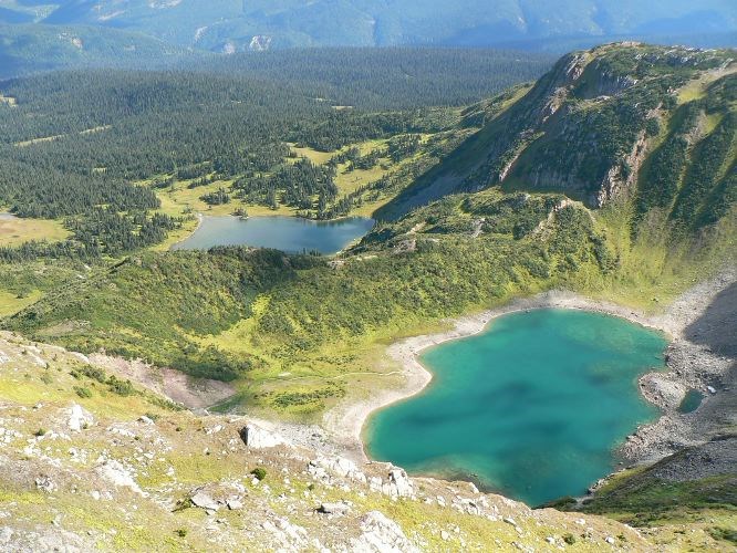
There are great views of the mountain ranges to the east from the ridge, as well as two alpine lakes in a bowl below. It is another 600 metres to the top of the north peak and 430 metres to the top of the south peak. Either direction allows for continuing along the ridge for further exploring. There is a viewpoint pullout on Highway 97 just to the west of Azouzeta Lake. This viewpoint has great views of the Murray Range and provides a good perspective on where the trail ascends and what options are available once on top.
For more information on this hike including airphotos, maps, GPS co-ordinates and trail photos refer the book Hiking Central BC which is available at local bookstores.


