
This week's hike leads to one of the easiest accessible glaciers in the region. Eagle Valley Glacier is an impressive sight as it towers over the valley. This relatively easy hike provides access directly to the base of the glacier. For those wanting to overnight at the base of glacier, a well stocked cabin is situated at start of the moraine deposits. The view from the cabin is spectacular so you won't find too many places where you can wake up to a panorama like this.
Directions
From the Yellowhead Bridge in Prince George, drive 202 km east on Highway 16 and turn right onto the Dore Forest Service Road. After 1.9 km, the road turns to gravel. At 3.9 km the road crosses the Dore River. At 8.1 km turn left onto the Dore South Forest Service Road. The right fork leads to the Ozalenka Valley Trail. At 13.6 km from the highway, the road crosses a small creek with a nice waterfall to the left of the bridge. After 21 km, there is a sign that reads "Eagle Valley Trail Left". Take the left fork, and drive 200 m over the Dore River to the parking lot. Watch for grazing cattle on the last sections of the road and the first two kilometres of the trail. There is a large trail sign on the east side of the parking lot. Follow the deactivated road east as this is the start of the trail.
Trail Description
The trail starts out on a deactivated road for 3.2 km. This old forestry road traverses the slope and gradually ascends to the forested trail at the end of the cutblock. There are large boulders and a few mudslides along the road which make the road impassable by vehicles. The forested trail quickly descends to the valley floor of Eagle Valley Creek. The trail follows the creek up the valley for the remainder of the hike. Approximately 200 metres past the 4 km marker, there is a unique, very large boulder resting beside the creek. The trail wanders through the valley bottom while passing many avalanche chutes with alder swells and boulder strewn debris piles.
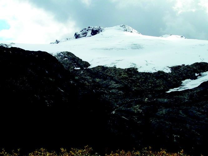
The trail is very flat in the valley bottom until the 7 km marker where it climbs steadily for 1 km. A cabin is located after 9 km on the hike. It is situated in a level area of the valley at the foot of the glacier. There are magnificent views of mountains on either side of the large glacier at the end of the valley. The glacier appears a lot closer than it actually is. It is a further 1.8 km to the toe of the glacier.
A couple of creeks from the meltwater of the glacier must be crossed in order to reach the edge. There are logs and bridges over the creeks at various spots.
The cabin is fairly new and very well stocked. There is a wood shed and outhouse at the rear of the cabin. The cabin can be reserved through the Ozalenka Alpine Club by calling (250)569-2596.
For more information on this hike including airphotos, maps, GPS coordinates and trail photos refer the book Hiking Central BC which is available at local bookstores.


