
The area between Francois Lake and Ootsa Lake might look remote on a map, and it is indeed accessible by only a few ways in or out, but is nonetheless heavily populated. An estimated 1,500 homes are tucked in amongst the lakes, fields and trees. Farmers, foresters, rural lifestylists and three First Nations call this pocket of earth home. Some call it paradise.
Paradise is burning.
The internal communities of that area have names like Wistaria, Tatalrose, Binta, Uncha, Danskin, Southbank (the southern terminal of the Francois Lake ferry), Grassy Plains (the defacto capital because it has a school and a store), and Takysie Lake where a fishing and camping resort acts as an anchor business of sorts.
There are cattle ranches, a bible camp, tourism operations (it's the northern access to Tweedsmuir Park), hay and grain operations and a famously interesting variation of people. In the greater Lakes District area it was known, in the last quarter of the 20th century, as Hazard County due to its colourful collection of ultra-ruralites and its lack of formal authorities.
It was a place where the average grandmother could change a flat tire, bake a basket of muffins or set a broken bone on any moment's notice.
Children there grew up knowing how to gut a fish by eight, reload the rifle by 10 and sharpen a chainsaw by 12.
Up until the 1960s the only two professions of note in that area were farmers and loggers. Starting in the 1950s-60s it attracted a subculture of religious fundamentalists, Vietnam draft dodgers, back-to-the-land practitioners and still more farmers and loggers.
It was also a place where Aboriginal populations outnumbered non-Indigenous people, Indigenous languages were still commonly spoken, and hunting and fishing still put a lot of a family's food on the table. Much of this is still true today.
For the most part, it was a peaceful place except for the wild vehicles on the dirt roads. When violence or property crimes did occur (alcohol and/or poverty were usually involved), sometimes the police would be called from Burns Lake, an hour's drive plus a ferry ride away, or sometimes a more local solution was found. The isolation was both a drawing card and a crippling element.
Guns and alcohol were staples of daily life, and it was a good 50 years ahead of Canadian Parliament on legalizing marijuana.
It was - and is - one of the places in B.C. most likely to have a Trump voter and most likely to have someone with the complete works of Aldous Huxley on the bookshelf. They might be neighbours. They might be the same person. It's a community that is both frayed and tight-knit at the same time.
The last 20 years have been transformative, as natural resource industries, small businesses, post-secondary education and social development has flourished there largely on the terms of the local residents.
If single words had to be used to describe the people of that community, terms like "independent" and "self-sufficient" and "anti-establishment" would come up.
Collectively, the ongoing nickname for this area is The Southside due to its geographic position across 90-kilometre Francois Lake. The people there, regardless of background or profession, are known as Southsiders. It has been a pejorative term in years long gone by, but that has largely faded into a literal reference today.
Historically, it is the traditional territory of the Skin Tyee, Nee Tahi Buhn and Cheslatta First Nations, the latter of which was infamously bullied out of homes and lands on the shores of Ootsa Lake to make way for the Kenney Dam floodwaters in the 1950s (the headwaters of the Nechako River). That act is still echoing through the halls of modern government and across the landscape of that locale.
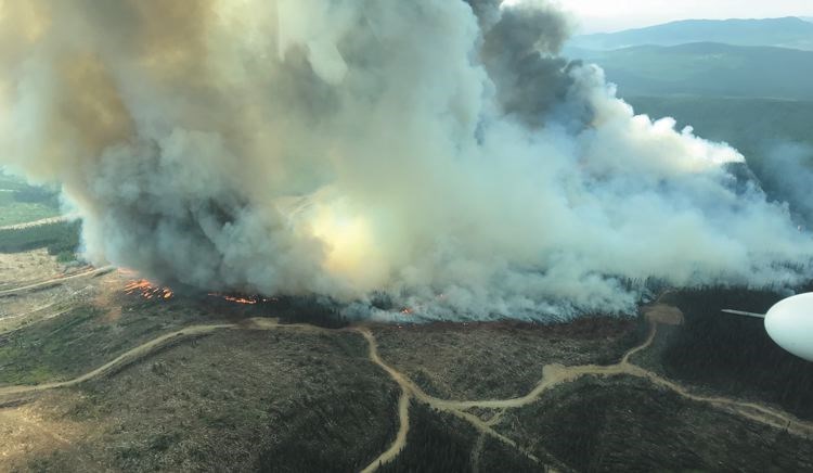
On July 31, a storm dropped a number of lightning strikes in this area. Spot-fires ensued. They aren't spot-fires anymore.
The Nadina Lake fire started directly west of Francois Lake just south of Houston. It was a collection of lightning fires merged, and spread north and south, then crawled around the head of the lake and has already burned more than 78,000 hectares, eating more than 40 kilometres deep into the Southside from the west. It threatens a similar set of communities on the northwest side of Francois Lake as well.
The Island Lake fire has grown to larger than 17,000 hectares, burning more than 20 kilometres in a mostly easterly direction to the tip of Francois Lake and down to the shoreline.
The Verdun Mountain wildfire is crawling through the heart of the Southside area, eating a hole about 17,000 hectares in size. This one is of greatest concern in terms of structures. There is a larger concentration there of homes, barns, machine shops, small businesses and other values. Two of highest profile are the Ootsa Lake Bible Camp and Takysie Lake Resort, both in the crosshairs of this blaze but still standing as of press time.
Not far away from that fire is a smaller one following the north shore of Cheslatta Lake. It was more than 20 kms across, as of last report, and had consumed another 2,600 hectares of the Southside. It goes by the name R11683 but locals call it the Cheslatta fire. Between the four (the Cheslasli fire is also a player in this drama, though further off), the Southside was being burned from all four directions and no farm or home was effectively safe, if it hadn't been destroyed already.
As of Tuesday, the BC Wildfire Service was reporting a fighting force on the Nadina Mountain fire of 49 firefighters, 14 helicopters and 67 heavy equipment.
The Island Lake fire was being worked, as of Tuesday, by 70 firefighters, eight helicopters, 23 heavy equipment, plus additional support shared with the Shovel Lake fire also burning in that same area, but closer to Fraser Lake.
Verdun Mountain was being actioned by 110 firefighters, 14 helicopters and 41 heavy equipment.
Additionally, said the BC Wildfire Service, there was a collective pool of resources at work of, in total, "365 persons" including "14 helicopters, and 166 pieces of heavy equipment shared amongst all fires that comprise the Babine complex."
Additionally, an influx of 21 fire trucks and 61 structural firefighters have arrived to help on the Southside.
The entire area was cleared of people last week, leaving most of those displaced to wonder if they had a house or business (or both) to go back to.
Some people stayed, despite spotty electricity, phone lines or cell service. They wanted to defend their homes, barns, shops and other structures. When friends and family attempted to join them, they were turned away by police and entry points like the northside Francois Lake ferry landing.


