
Doug Beckett is keeping his fingers crossed as a long-sought goal of establishing a trail system around Lost Lake on the western edge of Beaverly is coming down to the short strokes.
On behalf of the Beaverly Community Association, Beckett has been the lead on the proposal for 8-9 kilometres of paths for walking, horse riding, cross-country skiing and showshoeing as well as a portion suitable for wheelchairs.
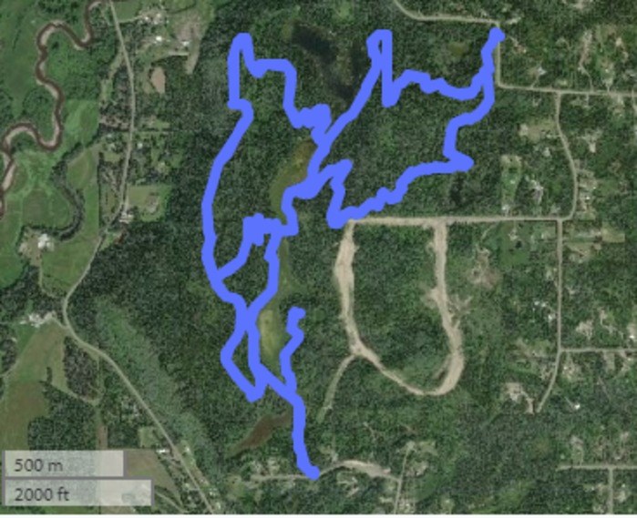
The culmination of more than 10 years of discussions and planning, it's now up for public comment on provincial government's Crown Lands website. (Click here to visit). The deadline for comment is this Thursday and from there, it will be a further 120 days for government officials to decide whether it's a go.
"I'm confident that we've had a lot of broad-based community input into the design and I'm confident that we are going to get a lot of favourable response but it's also nerve wracking because you just don't know whether everything you've done got input from all segments of society and if you've missed something," Beckett said.
While system as proposed is spread over about 130 hectares (325 acres) of Crown land around a "little lake that the community has called Lost Lake for eons," and a series of three wetlands that feed into the lake.
Beckett said it's home to a vast variety of trees, shrubs and plants as well as nesting sand hill cranes, bears, moose and, off and on, beaver, along with an "explosion of toads every summer."
"And if you're on the western edge of it, along the high ridge, you overlook the Chilako River valley and it's just spectacular, especially when the fall colours come along which is going to be occurring very soon," Beckett said. "It is so pleasant and relaxing looking out at the gold of the leaves and seeing the little farms nestled in."
As a matter of disclosure, he said his home sits immediately across from one of the three entry points proposed in the plan and his property will probably go up in value if the plan becomes reality.
"But that's not what's motivating me. It's maintaining wildlife habitat," he said. "We have bear wandering out from Lost Lake onto our property, moose and deer, fox and we have a ravine on the far corner of our property and so they go through our property to get to the ravine and we want to continue that wildlife movement."
The trail routes were designed with help from students in the University of Northern British Columbia outdoor recreation and tourism management program and Industrial Forest Service Ltd. which provided the software to map the system.
Challenges included figuring out how to lay a trail over an undulating landscape around the lake and beaver ponds while also staying away from nearby private property and keeping the slopes low enough for cross country skiing and use by wheelchair.
"That took an awful lot of designing with the engineering software to make access down to Lost Lake, which it runs along, workable and then to make the distances as long as possible so that it wasn't just a short, stubby little trail," Beckett said.
Approval pending, Beckett said the work will be carried out by volunteers while also going to different funding sources to pay for the materials.
"We'll need to put substrate down on the trails," he said. "We'll do the low spots initially but over the years the whole trail surface will get substrate on it because it's thin duft on clay and whenever it gets a little bit wet, you get significant damage. Even walking on trails causes damage."


