
Officials with the B.C. River Forecast Centre say that unusually fast snowpack melts, coupled with expected rainfall later in the week, could raise flood risks for the upper fraser region.
Officials did not expect that this would translate into severe flooding into the Nechako through Vanderhoof or Prince George. Snowpack levels have remained high this month in mountains feeding into Stuart Lake. But the Upper Fraser region as a whole is currently seeing snow basin indices at 264 per cent of normal, which generally is an indicator of a high risk of flooding. The area of most concern in the north is along the Bulkley River between Smithers and Houston. Also of concern is Burns Lake, where the current snow water equivalent is at 477 per cent of normal.
There have also been reports of flooding of some properties around Cluculz lake, a popular cottage area between Vanderhoof and Prince George.
"We do see some weather developing through this week and into next week that is concerning for flood risk. We've got another couple days of warm weather. We are expecting that some of the rising trends we've seen in rivers to continue with that rapid snow melt over the next couple of days. And then followed by wetter weather on Wednesday," said Dave Campbell, head of the B.C. River Forecast Centre on a conference call with media on Monday afternoon.
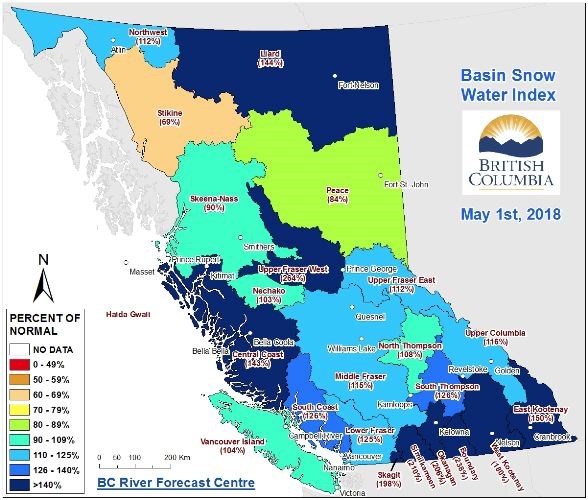
Overall across the province, the average for snow measurements was 168 per cent of normal as of May 1. This is up from an overall average of 127 per cent of normal as of April 1.
The snowpack melts have so far occurred earlier than normal, resulting in evacuation orders in some parts of the interior.
"Typically this is fairly early in the snowmelt season. We generally start around the early part of May and go to the end of June. I think we're obviously seeing that things are happening earlier this year and the forecast for the weather in the next while is expected to continue that," Campbell said.
Other areas of highest concern throughout the province were the Okanagan, Nicola, Boundary, Similkameen, Skagit and the Kootenays.
According to Chris Duffy, the executive director of programs of the Emergency Management B.C., 21 evacuation orders have been issued province-wide this year, affecting a total of 187 homes.


