
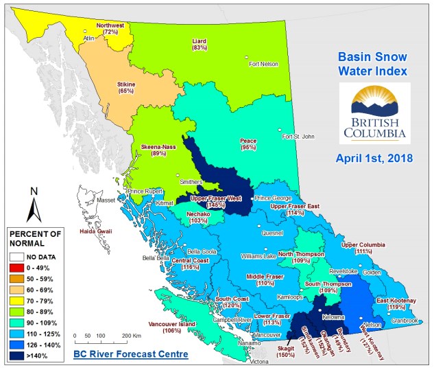
Higher than normal snowpack levels have placed Prince George, as well as other communities along the Upper Fraser West and Okanagan, at extreme levels of flooding, according to B.C.'s river forecast centre.
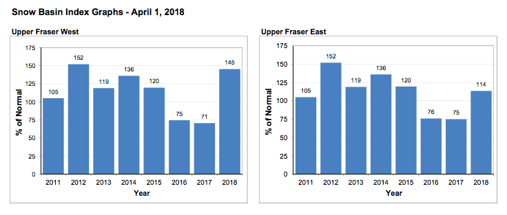
In a media conference call, hydrologist Jonathan Boyd said the Upper Fraser West region saw snowpack levels at 145 per cent above normal as of April 1st. Last year at around the same time, snowpack levels were at 71 per cent of normal. B.C.'s river forecast centre considers snowpack levels above 135% to be at extreme risk of flooding, although weather and rainfall levels in the coming weeks are also factors in assessing risk.
The Okanagan, Boundary and Similkameen were the only regions to see higher levels of snowpack. The Okanagan recorded the highest levels of snowpack, at 152 per cent, tying for the highest levels on record.
The high levels resulted from heavy snowfalls seen in February throughout the province. Overall, the snowpack was 127 per cent above normal, 52 per cent higher than last year. Boyd said the levels were close to those observed in 2012, when several regions saw significant flooding. Snow packs tend to accumulate more in May during La Nia years, such as this year.
Areas hit by last summer's wildfires, such as the Cariboo Chilcotin and the Okanagan, are likely to see flooding due to the reduced tree cover, which often slows the spring melt.
But Boyd noted that high levels of snowpack do not necessarily result in flooding along the Fraser.
"An extreme snow pack above 135 per cent of normal may not result in flooding if the melt is relatively slow and drawn out. This has happened many times in the past," Boyd said.
"Snow pack is one element of seasonal flood risk during BC's [spring] season. Weather patterns during the snow melt season play a critical role in whether or not flooding occurs. Intense or prolonged rainfall and extreme temperatures are important factors that can lead to flooding, even for areas with a near normal snow pack."
As a comparison, Boyd compared the current conditions to a heavy flooding season experienced by the Prince George area in 1948. In that year, the region had experienced an unusually cold winter, followed by a 30-day period with temperatures over 20 degrees Celsius from May to June.
"It was an extreme heat that caused the flooding in 1948," Boyd said.
The April 1st snow survey is the most accurate indicator of flood risk along the Fraser. By April, 95 per cent of the of average mountain snowpack has accumulated. Snow tends to begin melting in mid-April.
.png;w=120;h=80;mode=crop)

