
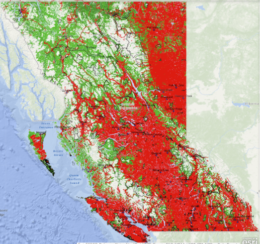
Conservation North has released a map showing the cumulative impact industrial activity has had on the province's forests.
It depicts roughly three-quarters of the province covered in a swath of red while an accompanying map shows how little old growth is left. It is the product of a project dubbed Seeing Red.
Conservation North outreach coordinator Jenn Matthews said in a statement the group “wanted to show what has actually happened in those forests that most of us can’t see.”
The maps were issued at a time when, according to the group, forests that have never been disturbed by industry are threatened by both industrial logging and a burgeoning bioenergy industry.
The group contends the forests that still stand should remain untouched in the name of curtailing climate change and subscribe to the claim that they do a better job of sequestering carbon than planted forest and offer great benefits in terms of biodiversity in addition.
"The scientific research does not agree; primary forests are in fact carbon assets whose greatest climate value is realized when they are left standing,” Conservation North director Michelle Connolly said in the statement.
The maps were issued the same week that British-based Drax, which owns the largest biomass power station in the United Kingdom, said it has reached a deal to buy Pinnacle Pellet, which operates four pellet plants in the Central Interior.
The maps can be found online at the Conservation North website.

.png;w=120;h=80;mode=crop)