
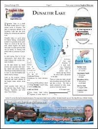
Dunalter Lake is a small lake located about 15 kilometres north of Houston. The lake is commonly referred to as Irrigation Lake and has good fishing for cutthroat and rainbow trout.
Dunalter Lake is a good place for family fishing, conveniently located in a popular public park. There is a dock in the day use area, where anglers can easily cast a line. In other spots the lake can be weedy, so boating with small boats or pontoons is popular.
In early spring, flies to try are chironomids, used while still-water fishing with a strike indicator (bobber).
As the lake warms up, hatch activity will increase with mayfly, caddis and midge hatches. The midges usually hatch through to June. In June the mayflies and caddis start to emerge.
Later in the summer, fishing dragonfly and leech patterns in the deeper water should work well.
Some popular lures used on the lake are Gang Trolls, Triple Teazers, Triplefish, and little Apex Trout Killers.
There is a motor restriction in place on Dunalter Lake. See the BC Freshwater Fishing Regulations for more information.
For some great fly patterns, check out Cory Koenig's expert tying at www.webflyz.com.
LAKE ACCESS
From Burns Lake follow Highway 16 west, about 15 kilometres past Houston, to a sign reading "Irrigation Lake". Turn left (west) onto a small road and follow for about half a kilometre to the lake.
There is a day-use camp ground and picnicking area near the lake, and also a dock. The lake is easily accessed by belly boats, pontoon boats and canoes.
Download Map: http://www.mapjungle.com/geoproduct/download/1465105?widgetID=18
Find and download hundreds of fishing maps from BC on The Citizen's fishing page.
http://www.princegeorgecitizen.com/section/princegeorge02&template=fishing_maps
Copyright 2011 by The Angler's Atlas


