
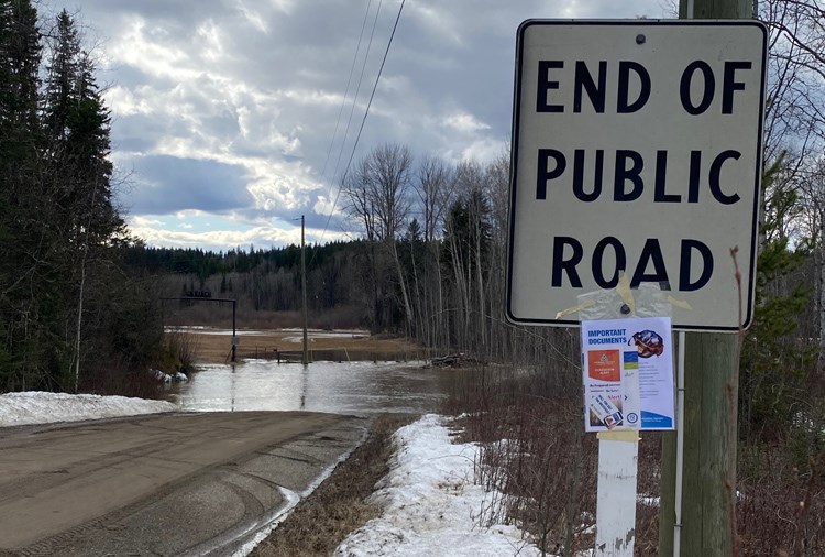
An area of Upper Mud River Road remains under an evacuation order Friday with river levels in the area expected to continue to rise and rain in the forecast.
The Regional District of Fraser-Fort George is concerned about 40 properties along the road, located about 35 kilometres southwest of Prince George off Highway 16 West, and residents have been told to gather their most valuable items and leave.
River levels in the Chilako River were rising by as much one centimetre every 15 minutes and grew by nearly 35 centimetres in one day, prompting the order on Thursday night.
“The concern is really about access in the area and how long that road’s going to be passable, because it’s really the only way in and out of that area,” said Renee McCloskey, the RDFFG’s manager of external relations. “The Lower Mud (River Road) has a couple of other routes in and out but for Upper Mud, that’s it.
“We know there will be people who choose to shelter in place and we can’t force them, but we’ve made them aware of what the risks are. That being said, we’ve also had others who have made the choice to evacuate.”
The area under evacuation order includes Upper Mud River Road properties with addresses that start with 24285 to the south and ends with 15780 to the north.
Warmer weather the past week and above-average snowpacks have created melting conditions that are stretching the capacity of rivers and creeks in the area and flooded fields are common.
“It’s certainly not unusual to have flooding and high water in that area, those residents who have lived there for a number of years are well-versed in what happens this time of year,” said McCloskey. “But what was a little different was how quickly that water was rising. That’s kind of what forced our hand on making the decision.”
“The fact this is happening in the midst of a pandemic makes it all the more stressful and challenging for people in the area and we wanted to make sure we have safe options for them.”
Bon Voyage Inn and the Sandman Signature hotel are available to provide free emergency lodging to residents for 72 hours while they make alternate arrangements. Pets might be accommodated, at an additional expense, but residents are asked to find other temporary homes for them.
Residents are being advised to take a 72-hour emergency kit which contains critical items such as medications, money and keys but only if they are immediately available. They are also being told to watch out for neighbours who might need a ride to leave the area. Transportation assistance can be provided through the regional district (call 250-960-4400) or Emergency Management BC (1-800-663-3456).
The regional district is advising people to use extreme caution around streams and rivers. High water can erode the banks and cause a collapse at any time and the currents are volatile and unpredictable.
“We’re really trying to get the message out about how quickly river levels and streams can change,” said McCloskey. “What looks like a normal stream bubbling through your property one day can, the next day, turn into something quite different that can impact either your access or your property.
“We want to make sure people are taking steps right now to have an emergency plan if they need to evacuate their property. Do they have an alternative place to go or do they have pets or livestock and what kind of arrangements need to be made for that? The best time to do that is before something happens.”
Showers and a high of 12 C are forecast for the Prince George area in Saturday with between five and 10 millimetres of rain expected with a possibility of thundershowers, which could bring 20 mm. After an overnight low of 1 C, a cloudy day is also forecast for Sunday and a high of 8 C.
Near Quesnel, two properties on the Soda Creek-MacAlister Road 10 kilometres from the junction of Highway 97 were ordered to be evacuated when flooding and saturated ground caused a mudslide which has closed the road in both directions.
Drive BC is reporting the Quesnel-Hixon Road is closed in both directions due to flooding between Price Road and Cottonwood River Bridge.
A washout on Highway 97, 4.82km south of McLeese Lake, has reduced traffic to one single lane and delays are expected.
Ten properties in Cache Creek have been evacuated and the village is under a state of emergency. Ten properties were added on Friday to the evacuation order. The Bonaparte River near Cache Creek is flowing a 20-year-high levels, with the water expected to continue to rise throughout the weekend.
Evacuation warnings have been posted by the B.C. River Forecast Centre for the Nazko and West Road rivers and waterways around Quesnel, Williams Lake, Alexis Creek, Anahim Lake and Cache Creek. An evacuation alert remains in effect for 29 homes on Boreland Creek near 150 Mile House.


