
Smoky skies continue to plague Prince George while wildfires burn west of the city, however there could be some relief on the way.
There a 60 per cent chance of showers overnight, which will help clear the air, but those clouds are also expected to bring lightning and that could cause more fires in the region.
“We are expecting some movement of wind and potential lightning and thundershowers moving towards the east overnight and as that moves through hopefully it will clear up some of our smoke,” said Sharon Nickel, communications specialist for the Prince George Fire Centre.
“But there’s not enough (rain) to make a big impact.”
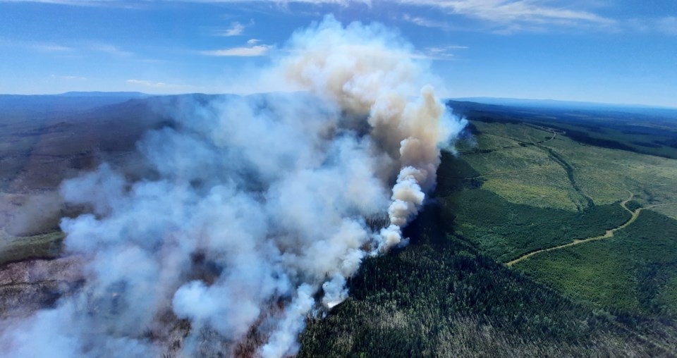
Three wildfires of note are currently burning in the Prince George area. Of the three, the Cutoff Creek fire two kilometres north of Big Bend Arm (between 80 and 100 kilometres southwest of Vanderhoof) is causing much of the smoke visible over Prince George. That fire grew from 1,900 hectares on Thursday to 8,930 ha by Friday afternoon.
“There was some significant growth with that fire, there was a big jump yesterday,” said Nickle. “That’s the big one coming in and especially given that we have winds from the west as well, it’s kind of blowing everything east our way.
“It’s considered an interface fire, so that’s probably why they’re working on the south side. I’m not sure if it’s a piece of infrastructure or residences but they’ll be working on controlling what they can to mitigate that.”
There are 53 firefighters, four helicopters and 11 heavy equipment machines fighting the Cutoff Creek fire, focusing on the south flank. The BC Wildfire Service has placed an area restriction order on the vicinity of the Cutoff Creek fire.
The Regional District of Bulkley-Nechako issued an evacuation alert that extends from 60 kilometres south along Kenney Dam Road to Knewstubb Lake and from six km west of Kluskus Forest Service Road along Natalkuz 500 Road to Knewstubb Lake. A map of the area under alert is on the regional district’s website.
The Chilako wildfire about 60 km south of Fraser Lake, which also sent smoke to Prince George, was held in check Friday and did not grow on size. It was 1,474 ha of late Friday afternoon.
“The crews working on that with the guards they’re putting in place had some good success with the burnoff operations and it is being held,” said Nickle. “We haven’t seen any growth in 24 hours, coming up on 48 hours, so that is a good-news story.”
The Tentfire Creek fire northeast of the city near Tumbler Ridge covers about 915 ha.
The Prince George Fire Centre, which basically encompasses the northeast quarter of the province, has 37 active wildfires. Of the 231 active fires in B.C., 152 are believed to be lightning-caused, 14 are human-caused and 65 are unknown in origin.
The fire danger in and around Prince George is listed at high or extreme in many areas and residents are being urged by the province to conserve water. Hot and sunny weather is forecast to continue all next week with highs ranging from 26 C on Sunday to 32 C on Wednesday. There’s a 30 percent risk of a thundershowers overnight Saturday and early Sunday morning but nothing beyond that in the weekly forecast.
Nickel is encouraging residents, especially those in rural areas, go to the provincial website www.firesmart.bc.ca to find out ways to reduce the risk of wildfires. If you see smoke, call the B.C. Wildfire Service dispatch hotline at 1-800-663-5555 or hit *5555 on your cell phone.
Drought is affecting much of B.C., especially in the south and central Interior after record high temperatures caused an extremely rapid snow melt in late-June and the first week of July. There’s been very little spring rainfall and that has led to water scarcity and low flows in area rivers and streams.
The drought level, on a scale of 1-5 with Level 5 being the most severe, is listed as Level 4 for the Salmon River watershed which drains into Shuswap Lake and adverse effects on fish habitat are expected. Level 3 drought conditions exist in the Okanagan Valley, the Nicola and Coldwater watersheds near Merritt, the Kettle River watershed near Grand Folks. Most of the other southern and central Interior watersheds are ranked Level 1 or Level 2.


