
As climate change threatens to thrust British Columbia into an increasingly unpredictable future, the province is calling on the public to provide input on a new plan to strengthen flood preparedness.
On Friday, the B.C. government released an intentions paper, From Flood Risk to Resilience in B.C., outlining how it hopes to balance public safety with a sustainable environment and stable economy.
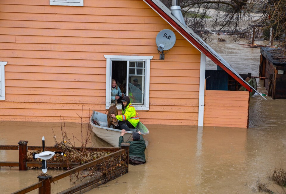
It points to the devastating floods of November 2021 that rocked the residents of B.C.’s Sumas Prairie, Merritt, Princeton and a number of First Nation communities. The flooding led to billions of dollars in damage, killed several people and hundreds of thousands of farm animals.
“Flooding is by far the most common, costliest disaster in Canada,” the report says.
The November 2021 floods were made two to four times more likely due to human-caused climate change, scientists have found. The report notes flood risks in B.C. are “substantial and continue to grow due to land use pressures and climate change.”
The intentions paper puts a growing focus on “safe flooding” zones, where natural floodplains and green infrastructure combine to reduce communities’ risk of death and destruction. Letting water move more freely would also support complex ecosystems and provide public spaces for recreation.
That's important as every year water threatens more lives and property.
Flooding getting worse
In calling for a B.C. flood strategy to “future-proof” the province, the documents says river flooding is expected to be 10 to 20 per cent more frequent. Local floods from heavy downpours, meanwhile, are expected to be 40 per cent more frequent.
That all comes as sea levels are forecast to rise at least one metre by the end of the century — squeezing many coastal communities between river and the ocean.
“Climate change is happening, and it is increasing flood risks,” the report says. “A warmer atmosphere leads to heavier rainfall events, earlier and more rapid snowmelt, and rising seas.”
And as more severe wildfires hit the province, they are expected to further destabilize the ground’s ability to absorb water, meaning water rushes over its surface, creating more intense peak flows.
Flooding has always been part of B.C.’s seasonal rhythms — annual riverine floods boost nutrient levels in downsteam estuaries and surrounding floodplains. Add humans to the mix, and it gets more complicated.
The intentions paper traces 40 floods over the past 120 years. In many cases, rivers are documented bursting their banks, sometimes from intense rainfall or rapid snowmelt, other times because of ice jams, dam failures, or debris floods in steep terrain.
On the coast, storm surges, tsunamis and high tides led to at least eight separate flooding events. In urban areas, stormwater sewers and urban landscapes blocked or overwhelmed by water have led to a number of incidents.
At other times, groundwater has risen to flood basements and underground carparks.
Whether natural or human-cause, the rising risk of flooding points to one thing: the need for a plan, says the government.
A four-point plan
The intentions paper lays out four areas where the B.C. government wants to prepare for flooding.
First, to better understand flood risk, the province is looking to create a B.C. flood mapping program to provide consistency and quality control in every corner of the province.
It's also seeking to carry out a provincewide flood risk assessment; strengthen dike regulatory processes and compliance; increase flood risk awareness for the public and businesses; and combine applied research and training with Indigenous knowledge.
Second, and on the governance side, the B.C. government is looking to improve the involvement of First Nations in its flood planning and decision-making. It also wants to review and modernize legislation, regulations, policies and technical guidance.
Third, the province is looking to improve flood forecasting and early warning systems. The intentions paper suggests creating flood emergency response plans at multiple levels, and before the flood hits, deciding on a blueprint outlining how to build back better.
Finally, it will all cost money. The province wants to invest more in pilot projects that avoid flooding, but also those that protect communities with no way to relocate. Measures need to be improved around tsunamis, flood proofing and flood insurance coverage, notes the paper.
And when people can move, the province is looking to put more money into a strategic retreat of people and infrastructure from high-risk floodplains. Such a course would be undertaken with all levels of government, First Nations and the communities affected.
The government hopes to finalize a strategy by 2023 and begin implementing it the next year.
Any British Columbian who wants to provide input on B.C.'s flood planning can do so through a written submission or online survey.


