
Google Maps is going into the wilds of B.C. this summer as Destination B.C. and the Northern B.C. Tourism Association partner to use two Google Street View Trekkers that are capable of taking 360-degree imagery in the more rugged areas of B.C. only accessible on foot.
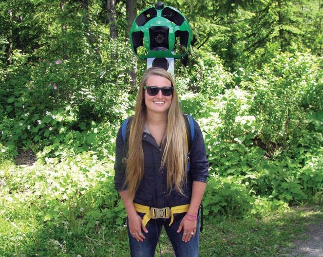
Teams that include from two to eight people will take on the challenge for the next 100 days of hiking rarely-traveled trails, exploring old-growth forests and climbing rugged mountains to capture images using the Google Street View Trekkers that weigh 40 pounds each and are housed in a backpack.
Once the images are captured by the technology that includes 15 separate cameras, they will be sent to the Google Maps team in California for processing and uploading to Google Maps that will take months to complete.
This is the biggest project taken on by a provincial tourism marketing organization and Google in Canada and will cover more than 1,500 kilometres. It took about nine months to prepare for the project.
"We know that the tourism industry is rapidly changing and destinations from around the globe are investing more and competing for consumer attention," said Clint Fraser, chief executive officer for Northern B.C. Tourism Association, during a press conference at Shane Lake in Forests for the World on Monday afternoon. "Even more important is the affect that advancements in technology have had on consumer purchase behaviour."
The Trekkers project will really capture the attention of those wishing to enjoy particular destination vacations, Fraser added.
"Many people are familiar with street view technology, essentially Google has taken the street view technology and has applied it to the areas inaccessible by road, which seems to be a pretty good fit for us up here in Northern British Columbia given the amount of roads versus the amount of land that we have," said Fraser.
"This is a really good fit for us because our wilderness is really our tourism product and our biggest asset."
Also in attendance was Nicole Bell, Google Maps spokesperson for Google Canada, Tasha Peterson, from Northern B.C. Tourism Association who demonstrated the Trekker and Maya Lange, vice president of global marketing, Destination BC.
"Bringing the Trekker to British Columbia, especially some of the more remote locations, is part of Google's goal to create the world's most comprehensive, accurate and usable map," said Bell. "More than one billion people around the world use Google Maps every month and the images collected for the next few weeks will help to put some of British Columbia's iconic landscapes on the proverbial map of tomorrow."


