
Water, water everywhere and nary a drop to drink.
It's not just an ancient mariner's old rhyme, it is a critical concern in the Peace-region and Geoscience BC is excited by what they are finding in their high-tech search for the stuff.
This past summer, the provincial earth sciences agency undertook a unique airborne geophysics program, an eye in the sky so to speak, to essentially give the area around Fort St. John an underground MRI. They were looking for water.
Water has not run completely out in the Peace-region, but this all-important natural resource has become stressed. In addition to all the residential and commercial users of water, an intense amount of petroleum extraction is concentrated in that area and that industry needs enormous amounts of water.
"We are finished the airborne geophysics. Now we are doing the interpretation of the data," said Carlos Salas, vice-president of their energy projects. "We also hope to do some 3D seismic data integration as well (from existing studies done by other scientists) just to make the picture that much clearer. When we put it all together we should have a really good model of what the water inside the rocks is telling us. All these various interested parties can use that information to inform their decision making."
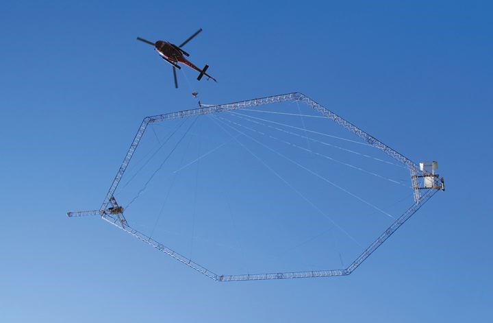
The project involved a helicopter flying a grid pattern over a huge tract of land. Slung beneath the chopper was a high-tech image machine that Geoscience BC obtained from a company in Denmark where it was invented. That country has a shortage of fresh water, so, Salas said, their need resulted in this tool being created, to the benefit of British Columbia.
The machine resembles an octagonal scaffold hoop. It hangs by wires from the helicopter, which flies at a speed of about 150 km/h at a height of about 60 metres.
"We hope, based on the results we are getting initially, very encouraging, that other regions will want to do this as well," he said. "It's not cheap (this study was budgeted at about $2.4 million), but in terms of bang for the buck, it is extremely efficient."
The bills were jointly paid by a number of interest groups working with Geoscience BC, from industry, government and First Nations.
"They don't always see eye to eye on a lot of things, but this is raw information they can all use for whatever their goals are, for water management. It is unique to have all three of these interest groups involved in one project together," Salas said.
The study area was approximately 8,000 square kilometres. This massive map will, once it is compiled, provide land-use planners quite a careful pathway to the water sources they will need.
"What we have discovered in that region is that the rivers are not fed exclusively by snowpack and rainwater. They are at least partially supplied from underground sources of water," said Salas. "Forestry needs it; agriculture needs it; oil and gas needs it; a happy, healthy, thriving community needs it but it is not always in the right place for everyone's needs. And then, on top of the users all trying to get access to water, there have been three or four years of drought up there. This will, we think, really be helpful for all those needs."
Although the numbers are not yet ready for discussion, said Salas, he can say that the researchers were hoping to see about 350 metres below the earth, using this airborne imaging devise. Instead, the subserface mapping went down 600 metres.
It also picked up more than just water. "It helped us spot quantity and also quality of water, these images can often tell if it is potable water or not," said Salas, but harder materials like gravel seams were also sometimes detectable. It wasn't sensitive enough to detect precious metals, but it's helpful to locate more than just liquid.
"The more we know of what's down there, the more informed the decisions can be about how we use our land-base," Salas said. "That's useful information if you are involved in natural resource industries, if you are a municipality, a First Nation, an environmental group. Everyone benefits from having the best knowledge."
Geoscience BC hopes to have the final report ready to unveil by the end of this year, and the additional hope is more of these sophisticated subsurface mapping projects will be called for in other parts of the province.


