
A drone hovered above the crowd of students and researchers gathered in a clearing by Willow River, the latest example of a new partnership between the College of New Caledonia and forestry industry partners focused on innovative technology.
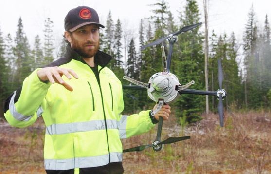
Just below the humming aircraft, Mike Wilcox of Spire Aerobotics controlled the device from a computer that collected the hundreds, sometimes thousands, of pictures it takes to produce a 3-D model of the terrain.
"It'll essentially fly back and forth taking pictures at set intervals and then each one of those pictures will overlap and then we'll stitch them all together," said Wilcox at Monday's afternoon demonstration to launch the college's Unmanned Aerial Systems project in partnership with FPInnovations and Quesnel-based West Fraser Mills.
"They'll line up because they're all georeferenced. Every time we take a picture it knows exactly what altitude and GPS coordinates it was taken."
The focus of the project is less on the drones - or Unmanned Aerial Vehicle (UAV) - than it is about developing innovative applications to interpret the data.
"Right now you can generate pretty pictures with the UAV," said Denis Cormier of FPInnovations, which is leading the project. "However what need to do is make sure these pretty pictures are turn(ed) into something useful for the forest industry."
"You need a system in place to be able to analyze that information and automatically generate an output."
That's where the college hopes to come in, said its director of applied research and innovation.
"We're trying to do two things," Hardy Griesbauer said. "We're trying to explore emerging technologies or innovative ideas that could benefit the forest industry so we work directly with our industry partners either to help develop them technology or help the industry adapt the technology and then we want to link that to the training of our students."
The idea is that students in the natural resources and environmental technology program will help conduct ground surveys and other forestry applications, learning the skills and tools that Cormier predicts are the future of the forestry industry.
"Instead of walking all that area, eventually these kids are going to take their UAV, put them up in the air and then video stream the information they have in front of them," said Cormier, adding he thinks the drones could eventually replace helicopters for aerial surveys.
But, at more than $100,000, Spire Aerobotics' UAV is no small investment. Like FPInnovations, the company only owns one, and both are in the early stages of seeing what value the device can offer their clients.
Just last week Cormier alongside college staff were taking measurements of the areas the project is studying, including some space in the CNC's research forest.
"That's exciting for us," said Griesbauer. "That's the intent of the forest. The forest was set up to have the college working with the industry on applied research projects together and to develop an outdoor training facility for our students."
The project is looking at seedling assessment or regeneration of the land after its been harvested, or affected by something like a fire. While the approach is unlikely to replace boots on the ground to test things like the health of a seedling, it can make the surveyor's lives a whole lot easier.
"Ideally we can make them more efficient with their time if they have a better idea of access to site, or the topography of a site or what's on a site," said Wilcox.
It can create the topography of the land and even produce at a resolution that shows space between trees.
"That helps in forest planning, road planning. we'll do access road surveys and monitoring to make sure crews and equipment can get into sites safely, a wide range of applications," said Wilcox, whose company purchased its UAV just last August. "The biggest things are basically quality and size and weight of the sensors that are available now. Before 16 megapixel cameras were huge and heavy whereas now they're tiny and light."
His aerial robot is known as a VTOL, or vertical takeoff and landing, which makes it more flexible than a fixed wing aircraft in terms of the space it can access and places it can land. But, it can't glide in the same way as small airplane, so it takes far more energy.
Transport Canada regulations require that it remain less than 100 metres above ground, Wilcox said, and while the routes are typically pre-programmed, the operator must have the ability to take control over at any time.
Griesbauer hopes to involve students in the fall and said the project acts as a draw for potential forestry students.
"This is cutting edge. It's really exciting and it's technology. So for young students who are coming into forestry, it's really great for us as a recruiting tool."
.png;w=120;h=80;mode=crop)

